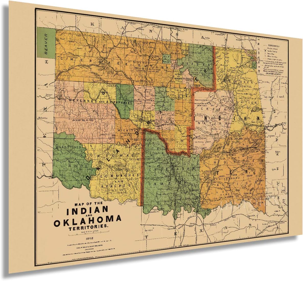
HISTORIX Vintage 1892 Map of the Indian and Oklahoma Territories - 24x36 Inch Vintage Map of Oklahoma Wall Art - Vintage Oklahoma Map - Indian Territory Map - Oklahoma Map Poster

$59.99
Features
VINTAGE MAP REPRODUCTION: You’ll love this high quality historic reproduction of 1892 Map of the Indian and Oklahoma Territories. Our museum quality maps are archival grade, which means it will look great and last without fading for over 100 years. Our print to order maps are made in the USA and each map is inspected for quality. This beautiful artwork is a perfect addition to your themed decor. Vintage maps look great in the home, study or office. They make a perfect gift as well.
MUSEUM QUALITY: This high quality map print will be a great addition to your vintage-themed wall. Don’t waste money on cheap-looking, thin paper posters. We use thick, fine art print quality matte paper. Our professional’s choice matte paper displays artwork in high detail without glare. The color is vibrant and text is easy to read. When framed, this map looks absolutely stunning.
A LOOK BACK AT HISTORY: This is an impressive, historic reproduction of 1892 Map of the Indian and Oklahoma Territories. This print is from an original found in the maps and geography division of the US Library of Congress. A true, accurate piece of history. See our product description section for more fascinating information about this historic map and its significance.
READY TO FRAME: This 24 x 36 Inch print includes a 0.2 inch border for a perfect frame fit and look. Our maps are designed to fit easy-to-find standard frame sizes, saving you money from having to pay for a custom frame. Each map is inspected for quality and shipped in a rigid tube.
HISTORIX: We love history and art. Sometimes old maps have tears, folds, separations and other blemishes. We digitally restore and enhance maps while keeping its historical character. All our maps are proudly made in the USA. Customers all over the world love our vintage maps and we know you will too.
Details
Discover the fascinating history of the Indian and Oklahoma Territories with our HISTORIX Vintage 1892 Map. This high quality reproduction captures the beauty and detail of the original map, ensuring it will be a cherished piece of art for years to come. Made with archival grade materials, this map will remain vibrant and fade-free for over 100 years, adding a touch of vintage charm to your home or office décor. Don't settle for cheap imitations - choose a museum quality map that truly tells the story of this significant time in history.
Upgrade your wall with our Vintage Oklahoma Map. Unlike flimsy paper posters, our map is printed on thick, fine art quality matte paper that displays vibrant colors and ensures easy readability. Its large size of 24x36 inches makes it perfect for a focal point on any wall, whether it's in your living room, study, or office. When framed, this stunning map becomes a conversation piece, capturing the attention of anyone who enters the room. Treat yourself or someone special to this beautiful vintage artwork that stands out from the ordinary.
Step back in time with our exceptional reproduction of the 1892 Map of the Indian and Oklahoma Territories. This map, sourced from the maps and geography division of the US Library of Congress, offers an accurate glimpse into the past. Marvel at the intricate details that showcase the landscape of these territories as they were over a century ago. Immerse yourself in the history and significance of this map, as every corner reveals a story waiting to be discovered. Add a touch of nostalgia and intrigue to your space with this remarkable piece of history.
You can trust our HISTORIX 1892 Map to fit seamlessly into your existing frame collection. Measuring 24 x 36 inches, it comes with a 0.2 inch border to ensure a perfect fit and look. Say goodbye to the hassle and expense of custom framing, as our map is designed to fit standard frame sizes readily available. We take pride in the quality of our maps, which is why each one is carefully inspected before being shipped to you in a rigid tube for maximum protection. Enhance your walls with a map that embodies both convenience and top-notch craftsmanship.
At HISTORIX, we believe in preserving history through art. Our team of experts digitally restores and enhances vintage maps while maintaining their historical integrity. Our love for history and art is evident in every map we produce. As a proud US-based company, we strive to deliver the highest quality products to customers all around the world. Experience the allure and nostalgia of our vintage maps and join countless others who have fallen in love with these remarkable pieces. Begin your journey into the past today with our 1892 Map of the Indian and Oklahoma Territories.
Discover More Best Sellers in Maps
Shop Maps
 Maps - National Geographic United States Wall Map - Executive (43.5 x 30.5 in) (National Geographic Reference Map)


Best Maps Ever Washington State Parks & Federal Lands Map 24x36 Poster (Camel & Slate Blue)
Maps - Best Maps Ever Washington State Parks & Federal Lands Map 24x36 Poster (Camel & Slate Blue)

 Maps - Gifts Delight Laminated 24x30 Poster: Diagram Collection Israel Political Map - More Maps, Diagram and Concept Wiring Diagram

Dallas County Detailed Arterial Wall Map (36"x38"") w/Zip Codes (laminated)
Maps - Dallas County Detailed Arterial Wall Map (36"x38"") w/Zip Codes (laminated)
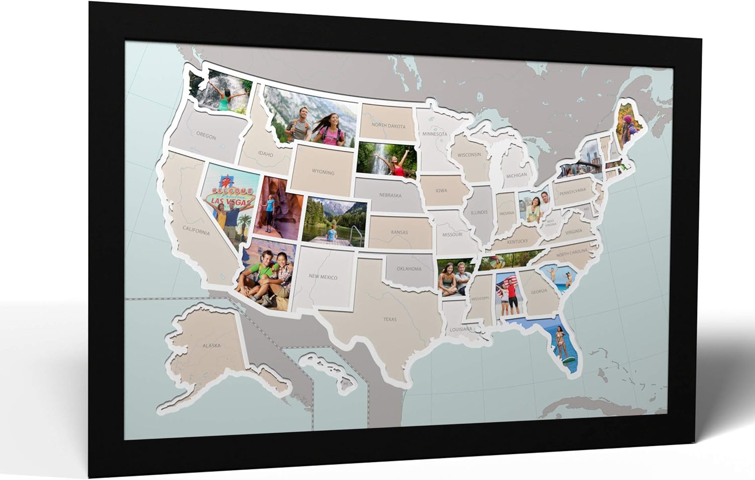
50 States USA Photo Map - Frame Optional - Made in America (Printed Map, Black Frame)
Maps - 50 States USA Photo Map - Frame Optional - Made in America (Printed Map, Black Frame)

 Maps - Home Comforts Large Detailed time Zones map of The United States-12 Inch by 18 Inch Laminated Poster with Bright Colors and Vivid Imagery-Fits Perfectly in Many Attractive Frames
 Maps - Map Your Travels National Park Travel Quest Scratch-Off Map Print | Includes Wood Frame and Scratch-Off Tool (12"x18")
