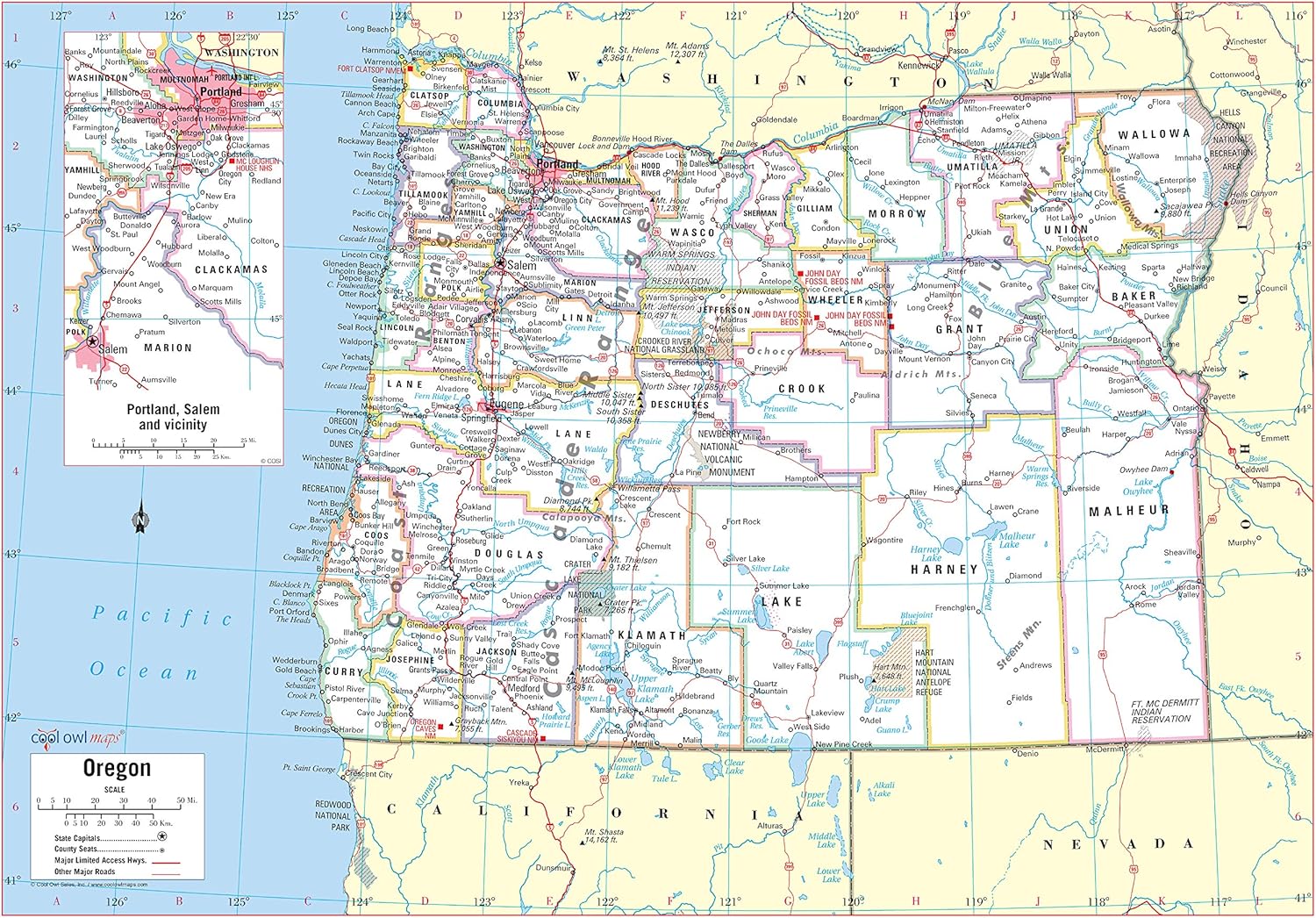

Features
- Large Print for easy reading
- Major Geographical features
- All counties and their capitals
- Size 34"W x 24"H inches (paper or laminated)
- Made/printed in U.S.A. 2020
Details
In search of a striking and informative wall decoration for your home or office? Look no further than the Cool Owl Maps Oregon State Wall Map Poster! Designed with meticulous attention to detail, this large print map features all major geographical features of Oregon, making it a captivating piece to hang on your wall. Measuring 34"W x 24"H inches, this poster is printed on high-quality paper, ensuring easy reading and durability.
Whether you're an Oregon native or simply have a fascination with this beautiful state, this map is a must-have. With its inclusion of all counties and their capitals, it serves as a convenient reference for both locals and visitors alike. Marvel at the intricate representations of rivers, mountains, and cities that make Oregon so unique. You'll find yourself lost in the details, discovering new landmarks every time you gaze at this captivating map.
We take pride in offering you a map that is more than just a poster. The Cool Owl Maps Oregon State Wall Map Poster is a piece of art with a purpose. Whether you choose the paper or laminated version, rest assured that you're receiving a product made with utmost care and precision. As a bonus, the map is proudly made and printed in the U.S.A., ensuring top-notch quality and supporting local businesses. Bring a touch of Oregon's charm to your space with this stunning map poster.
Upgrade your wall decor with the Cool Owl Maps Oregon State Wall Map Poster today! Whether you hang it in your living room, office, or classroom, it is sure to impress anyone who lays eyes on it. Don't miss out on the opportunity to own this beautiful piece of cartographic art. Experience Oregon in a whole new way. Order now and embark on a journey through the diverse landscapes and rich history of the Beaver State. Click here to order now!
Discover More Best Sellers in Maps
Shop Maps
 Maps - 8” x 16” Labeled World Practice Maps, 30 Sheets in a Pack for Social Studies, Geography, Map Activities, Drill and Practice, Current Event Activities, Learning Games and More

House of Doolittle Write On/Wipe Off Laminated United States Map 38 x 25 Inch (HOD721)
Maps - House of Doolittle Write On/Wipe Off Laminated United States Map 38 x 25 Inch (HOD721)

Wall Pops WPE99074 World Dry Erase Map, Multicolor
Maps - Wall Pops WPE99074 World Dry Erase Map, Multicolor

Maps International Glow in the Dark Constellation Map – Illuminates After Dark – 33 x 23
 Maps - Maps International Glow in the Dark Constellation Map – Illuminates After Dark – 33 x 23

Rand McNally State Maps: Georgia and South Carolina (2 Maps)
 Maps - Rand McNally State Maps: Georgia and South Carolina (2 Maps)

Utah State Wall Map - 14.75" x 17.75" Laminated
Maps - Utah State Wall Map - 14.75" x 17.75" Laminated
 Maps - Black Cork Globe with Push Pins - 6” Globe with Map of the World and Rotating Stand for Children or Adults, 100 Metallic and 100 Colored Push Pins - World Map for Home, Office, Classroom, Travel, Kids

Maps International - Scratch Off USA Map Golf Print - Gifts for Golfers - 17 x 22 inches
Maps - Maps International - Scratch Off USA Map Golf Print - Gifts for Golfers - 17 x 22 inches

